Accurate and accessible geographic data is a cornerstone citizen-centred town planning just as much as it is central to the emergence of readily accessible town planning software, that helps town planners in their everyday work.
At PlaceChangers, we are passionate about leveraging planning data to transform urban planning software and empower town planners with tools like our Place Analytics and Online Engagement software.
Data helps underpin plans, community needs, impact reviews, and help communicate complex proposals in easy-to-access interactive community consultations. A thriving digital planning environment will depend on ready access to reliable, trustworthy, and federated data to make digital planning a reality.
This article focuses on the growing role of open map data in urban planning. We’ll examine how well-known open source frameworks, such as OSM, complement formal sources like Ordnance Survey (OS) data and enable innovative applications, from pedestrian accessibility analysis to public space planning.
The Evolving Landscape of Planning Data Accessibility
At the time, when one of our founders, Seb Weise, completed doctoral training, access to information for town planning projects was still a lot more costly and time consuming than it is today. Key data sources were behind paywalls or restrictive licensing conditions. Data came in hard-to-access formats, such as by download, or spreadsheets.
In the past couple of years this has changed dramatically. A key point was the adoption of what’s known as the Inspire directive by the EU into UK law, which required public authorities to adopt clear standards to publish spatial data.
Open data is a term that describes data that “anyone can freely access, use, modify, and share for any purpose” (see more).
To date, the boundaries between open access and closed access information sources is more blurry than ever:
On the one hand, open data regulations made traditional surveying institutions, such as Ordnance Survey, publish data in open access format.
On the other hand, open frameworks, in particular OpenStreetMap (OSM), a collaborative, open-source approach to mapping, have shown the value of user contributions, with its source data now embedded in Google Maps and other applications.
Now there is a huge array of sophisticated applications for interactive maps and end user applications from navigation, urban design, town planning, place search, and more.
Check out our related article: Urban Planning and Design Software: Tools for Planners in 2024
How Map Data Was Traditionally Prepared and Its Challenges
As a government agency, Ordnance Survey (OS) has been a cornerstone of urban planning, land management, and navigation across the UK, offering precise data on everything from property boundaries to transportation networks.
In the case of official country-level map agencies, the source of information comes from contributors, such as official agencies, or register and cadaster information with professional surveyors and cartographers using advanced technologies such as aerial photography and GPS.
In 2015, OS made a significant step toward accessibility by releasing a range of its geographic data under the Open Government Licence. This open-access initiative allowed free use of datasets such as OS OpenMap, OS Terrain, and Boundary-Line for non-commercial purposes.
The release aimed to stimulate innovation and democratise access to geographic information, empowering smaller organisations and community groups to use the data for local planning and analysis.
The availability of OS data in open formats has complemented the open mapping ecosystem, enriching the tools available for town planning and public engagement.
Emerging Trends in Open Map Data and Urban Planning Software
Open mapping frameworks promise a word where more data than ever is user-generated.
Often referred to as the "Wikipedia of maps," Open Street Maps allows individuals to contribute data about roads, buildings, landmarks, and natural features, creating a detailed and dynamic map of the world. Unlike traditional mapping platforms, a key strength of OSM lies in its adaptability and community-driven updates.
Contributors can edit the map to include local insights, such as newly constructed roads or amenities, ensuring that the data remains current and relevant. This approach excels in flexibility, allowing users to customise maps for specific needs.
Taking OSM as an example for an open access source that benefits from global coverage, we looked at previous reports on data accuracy. This gives a perspective on suitability for various applications in town planning. Here are some key conclusions:
- Coverage in traditional western countries is high: For instance, a review by Herfort et al. showed that Europe and North America had relatively high completeness rates (71% and 64%, respectively), while regions like South Asia and Sub-Saharan Africa scored significantly lower. Globally, only 14% of analysed urban centres had building data completeness exceeding 80%, while 69% had completeness below 20%, with marked disparities across world regions.
- Completeness depends on population density: In another study, Zhou et al. reviewed 13,000 cities worldwide and concluded that completeness levels were strongly correlated with population density but revealed that less than 9% of cities globally achieved completeness above 80%.
- OSM data is ok for work that does not require highly precise positioning: A study by El-Ashmawy evaluated OSM's positional accuracy using detailed surveying as a reference. The findings showed that OSM data for a specific campus in Saudi Arabia achieved an average positional accuracy of 1.57 metres, sufficient for general planning and mapping applications at scales of 1:5000 or smaller. This accuracy level supports its use in preliminary planning and urban development but suggests limitations for highly detailed or regulatory-specific applications.
These reviews show OSM is most suitable and reliable in Western countries, especially Europe, where coverage is high, and for applications that do not depend on high levels of spatial accuracy.
Comparing OpenStreetMap and Ordnance Survey Data
Feature | OpenStreetMap (OSM) | Ordnance Survey (OS) |
Data Source | User-contributed | Professional surveyors |
Coverage | Global | UK-focused |
Accessibility | Free, open-source | Limited, some open data |
Accuracy | Sufficient for general use | High precision |
Use Case | Dynamic updates, customization | Regulatory compliance |
Recent UK initiatives
In the future, we may see many more specialised portals and sources for map data and related information. As is often the case, the key is about trust, and critical mass. Do I trust the data? And does this information source have sufficient coverage?
As for England, the UK government has been trying to address the problem of consolidating map data across districts and municipalities through a new ‘one-stop’ shop for planning-related information.
The new governments’ planning data source at https://www.planning.data.gov.uk is advertised as “A platform to help you create services to inform planning and housing decisions in England” and the government aims to provide a framework here for other third party providers to add to and complement data relevant to planning.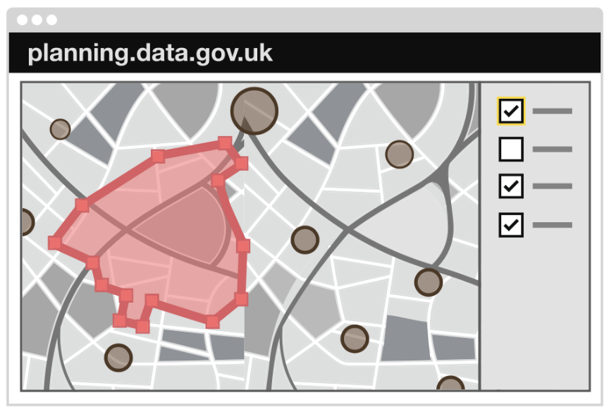
Government departments who publish data on their own website can add to the planning data hub, which in turn makes the spatial information available for the wider public and town planners to use, as well as enabling development of digital services.
Empowering Town Planning with Open Data and Innovative Tools
Readily access to trusted, consistent, and predictable information sources enables novel town planning software and services.
Take for example PlaceChangers place analytics, which is a comprehensive data tool to help town planners cross check a place, neighbourhood, or site based on configuring an impact area around their project.
You can define an impact area.
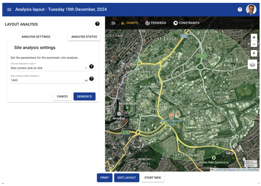
Within that impact area, the PlaceChangers place analytics tool draw in a range of contextual information from open sources, including OSM and Ordnance Survey for points of interests, schools, food outlets and more, along with information from Ordnance Survey for more specific and official designations, such as open spaces and flood risk zones.
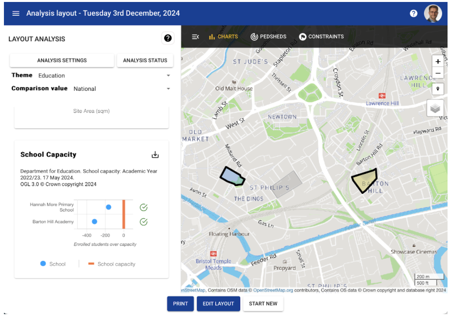
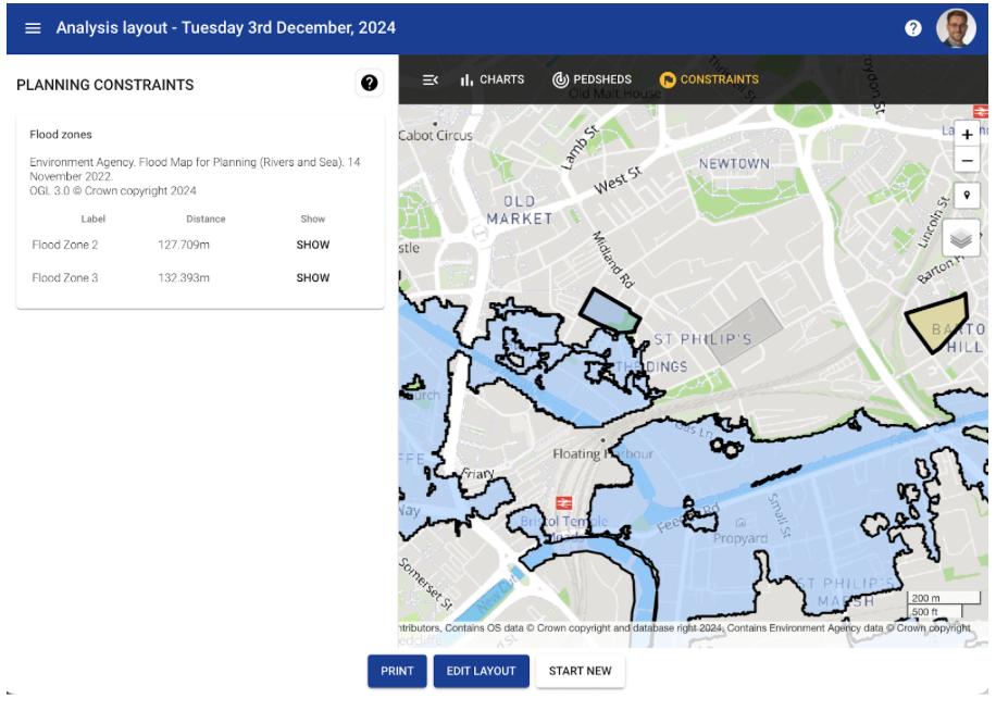
The tool relies on path connectivity, partly enabled by OSM-contributed information to help estimate the walkability and access to a range of local social infrastructure assets.
A recent play plan study showed the power of combining unofficial user-contributed information on play and open spaces with that from Ordnance Survey’s officially designated play spaces, enabling the team with the identification of a range of facilities and assets, which were not captured in open data sources. They then were able to generate relevant access analytics for different user groups, such as young children, or older teenagers, based on different access needs.
The place analytics tools did enable editing map content that was loaded in so that any additions or corrections could be made easily.
Future of mapping data
The future of mapping is rapidly evolving toward a more dynamic, interactive, and personalised experience. Modern maps are no longer static representations of space but live platforms that adapt in real-time to changing conditions and user needs. These innovations are revolutionising how individuals and communities interact with geographic data, making maps more relevant and responsive than ever before.
As maps become increasingly personalised, they cater to specific user preferences, whether highlighting cycling routes, identifying wheelchair-accessible paths, or recommending restaurants based on past visits. This trend toward individual-focused mapping leverages advances in machine learning and geospatial analytics, enabling maps to offer tailored suggestions and predictive insights. In the future, we can expect maps to integrate seamlessly into augmented reality (AR) applications and smart city ecosystems, creating an even richer, more interactive experience that empowers users to navigate and engage with their environments like never before.
OpenStreetMap (OSM) has proven to be a reliable and accurate resource in many Western countries, complementing formal mapping sources like Ordnance Survey. Its open-access nature and user-generated data make it a powerful tool for broad urban planning and analysis, offering sufficient detail for many applications without the costs associated with proprietary datasets.
